Mel Gray – 31/5/2020
From 2002 to 2008 my parents managed sheep stations along the Darling-Baaka River around the Tilpa area. During visits home when there was a flood event expected, I remember the fax machine would ring every morning with a warning – a rise in the river of xyz metres is expected in your area in xyz weeks’ time. Get prepared!
Growing up on our farm in the flood-zone of the Clarence River, the warning time for floods was days at best, and the impact to our lives and my parents business was all consuming. Like a well-oiled machine, we’d have the cattle and machinery to higher ground, the furniture lifted. Time to settle in and marvel at the awesome power of a Clarence River flood.
The gift that was left of thick rich fertile silt, up to several feet deep, would enrich and sustain the floodplain landscape, and my parent’s business, for years. The salt water that inevitably creeps up the Clarence for several hundred river kilometres in dry times, pushed well back out to sea. The nutrient rich floodwaters kick starting the web of life in the prawn and crab rich estuaries like the Broadwater and Wooloweyah Lagoon and the coastal recreational and commercial fishing grounds off the coast of Yamba. Sea food heaven.
Now out west, we looked forward to experiencing the mighty Darling Baaka in flood. So we’d wait. And wait, and wait. The river levels remained unchanged, after several weeks the faxes would stop.
 Mum in the Darling Baaka at Tilpa, circa 2004
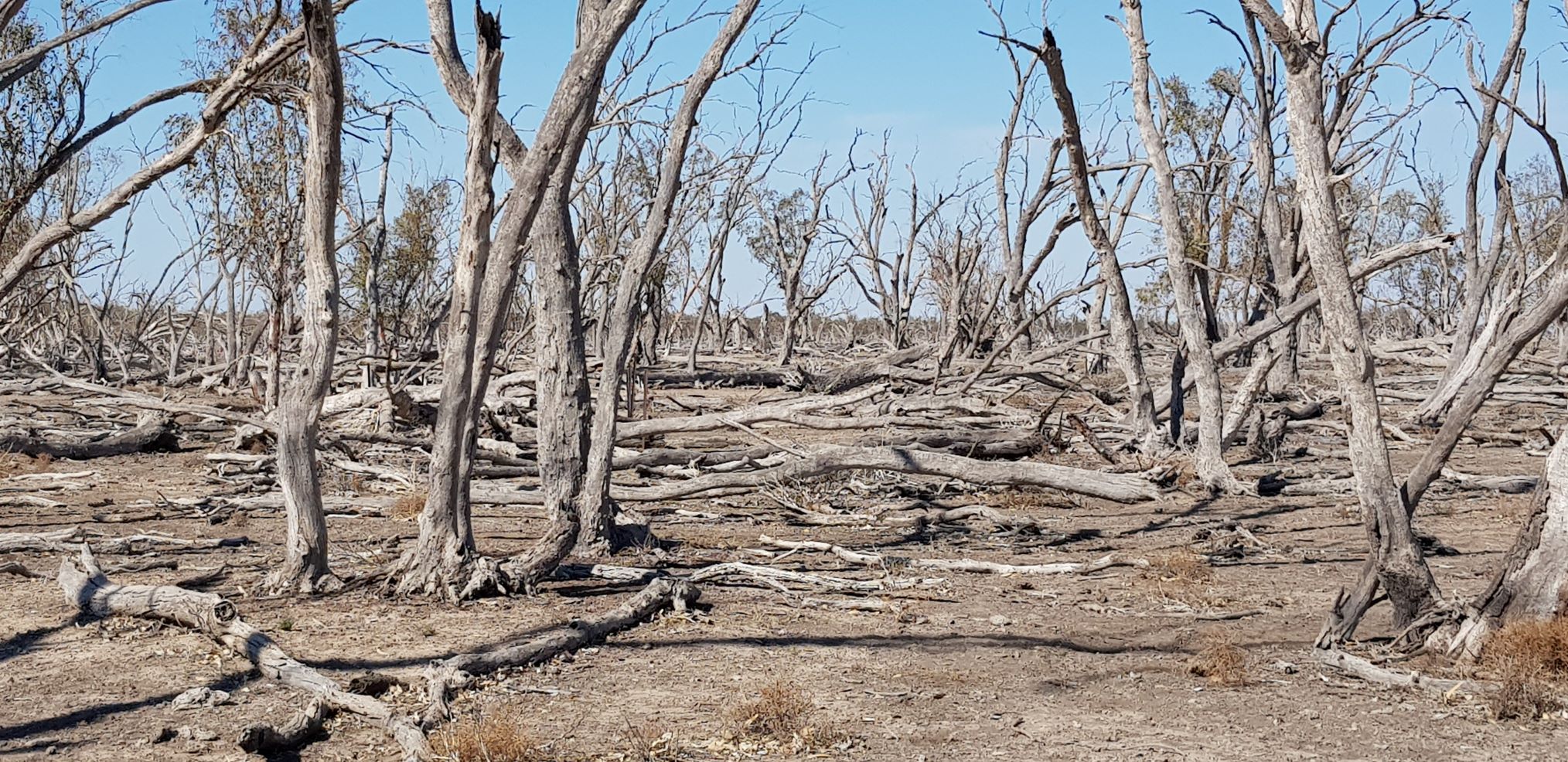
The floodplains remained dry, dusty, and without the rich covering of fertile silt. The rains that triggered the teasing faxes had fallen many hundreds of kilometres away. We’d heard stories of water skiing on the many enormous ephemeral lakes in the area. They remained empty. By now, almost two decades on, even the centuries old Red Gums are dying.
Since the 1990’s, floods along the Darling Baaka have become smaller and less frequent. As a consequence the land, animals, people and economies have been dying.
The impact on First Nation communities is heart shattering. The average life expectancy for a male in Wilcannia is 37. The Baaka is the blood of the Barkandji People and without the river they are dying.
What is happening on the Darling Baaka is cultural genocide.
 ABC News April 2018, Wilcannia
I moved to the Macquarie Valley in 2011, and fell head over heels in love with the Wambuul Macquarie River and the amazing internationally significant Ramsar listed Macquarie Marshes.
I volunteered a lot of my time restoring the riparian zone around Dubbo with our local BushCare group.
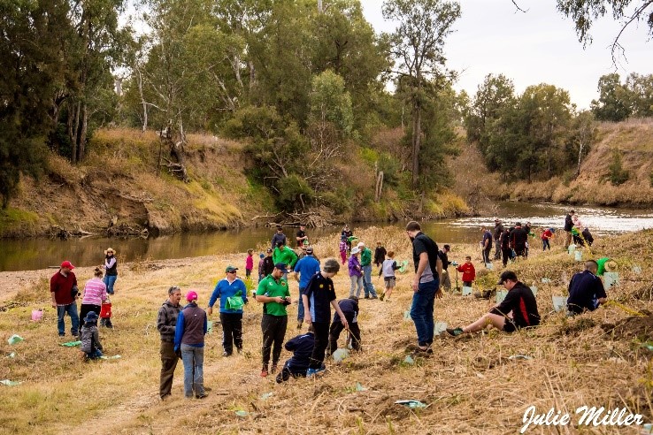 Community tree planting day July 2017
I joined a kayak club and got to know the river and Marshes well. I started a grassroots community group, and became an environmental advocate.
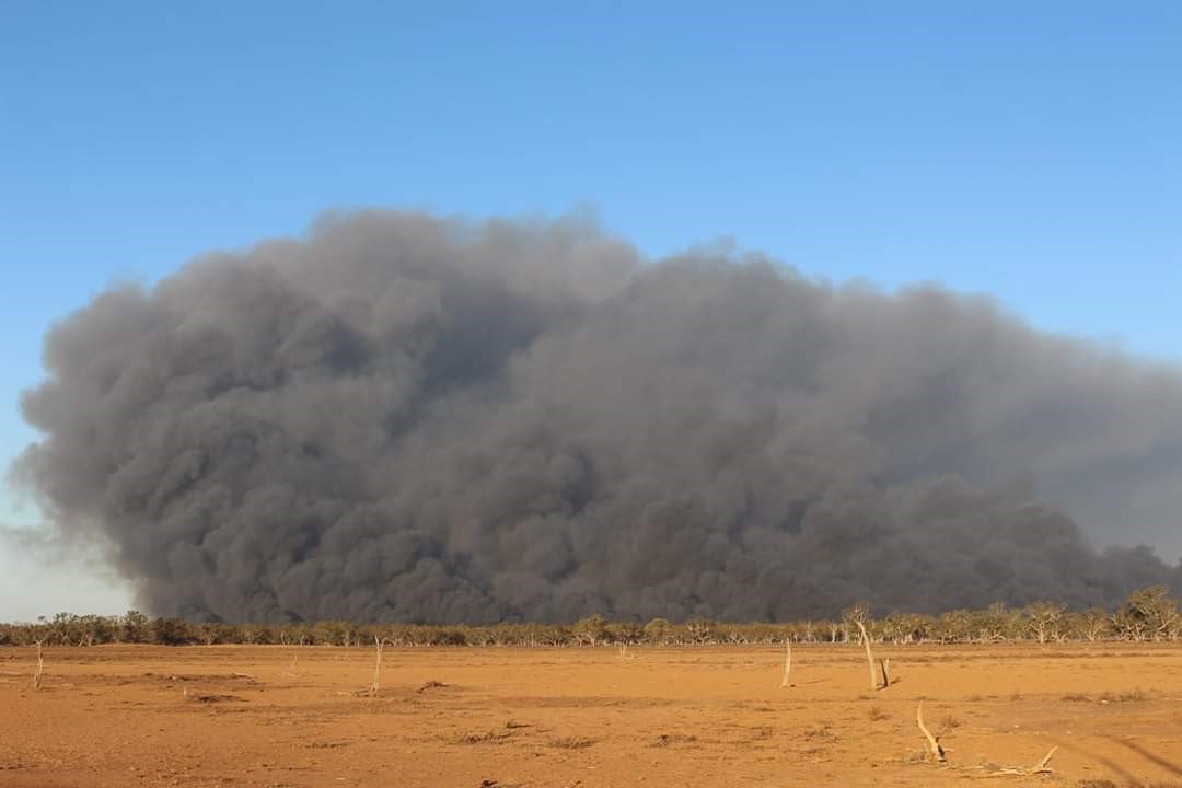
The summer of 2019/20 was shocking in the Macquarie Valley. The sharp severity of the drought was unprecedented. The frequency and intensity of the dust storms was actually a little scary.
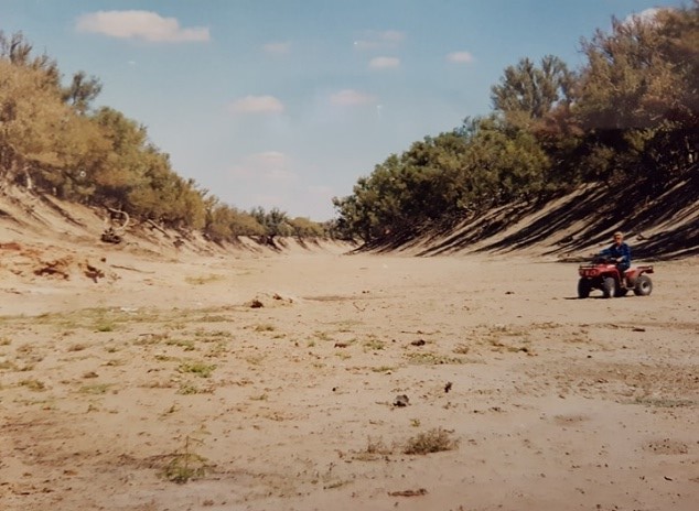
The Warren weir was raised by WaterNSW stopping flows beyond. Downstream, the river rapidly dried up to a series of disconnected green pools.
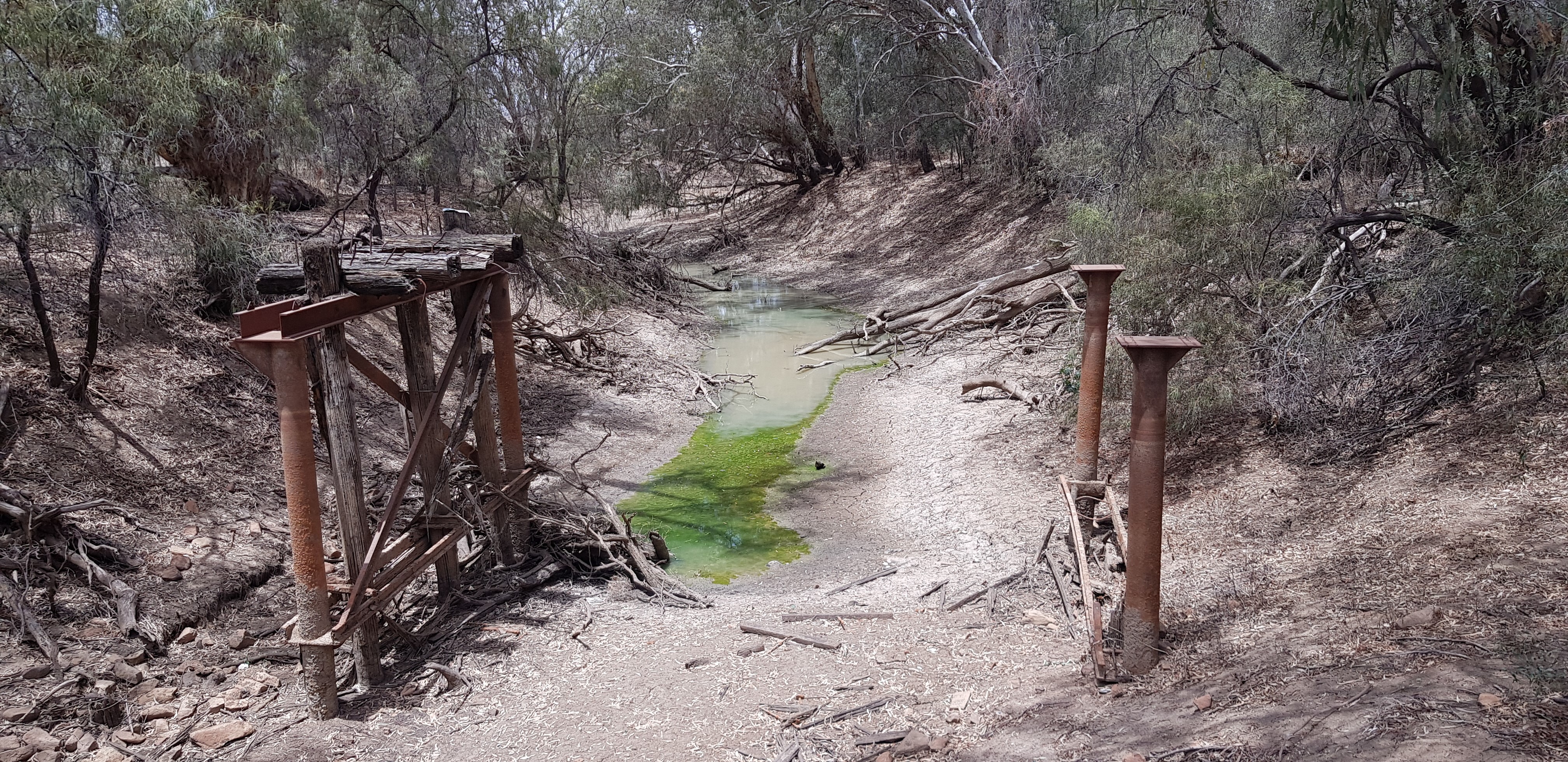 Macquarie River, 20km downstream of Warren NSW, November 2019
Insurance populations of turtles and fish were rescued from the river and secured in hatcheries by environmental agencies. Despite commendable efforts from the recreational fishing community to rescue as many fish as possible, mass fish deaths resulted.
The Macquarie Marshes were parched. There hadn’t been any surface water in the core Marsh since January 2019. The impact of years of ‘tight’ river management was evident – there was far less water around, and it disappeared very quickly.
 Dead Red Gums, Macquarie Marshes August 2019
Critical human need and stock and domestic requirements had not been met along the creeks downstream of Warren or the Lower Macquarie.
There was a shocking loss of wildlife as a result. Mobs of kangaroos perished, many 50 year old plus turtles died, and we lost some of the oldest mussels known to exist in our fresh water rivers. The loss of vegetation meant less habitat for many and varied water dependent animals, fish and birds.
The North Marsh reed bed (the largest reed bed in the Murray Darling Basin) caught a lightning strike in October 2019 and about 5,000 ha was burnt.
 North Marsh reed bed, October 2019
It was a tough time for the Traditional Owners and Elders, the landholders, recreational fishers, the whole community. It was a tough time to be an environmentalist.
We knew the reed beds need flood water ASAP. While they shot up after some rain fall that summer, we understood that they were using what little precious reserves their rhizomes held, making floodwater even more critical to their recovery.
The Rains Came!
The floods came in February 2020, entering the Macquarie in several events through the Bell, Little and Talbragar Rivers – all of which are downstream of Burrendong Dam.
Immediately, from the very first peak of the first flow, permission is given for water to be pumped under a licence type called “supplementary”. Supplementary access has the lowest priority of water access in the rules, and should only be allowed once critical human need, and stock and domestic requirements downstream had been met. However because the phrase FORECAST TO BE MET is in the rule, pumping was allowed. The critical environmental and human needs downstream were considered to be FORECAST to be met in several weeks time.
This anomaly means a type of take that should have the lowest priority, in real life gets the first water after a critical drought – before the environment and before humans.
The critical need for water in Macquarie Marshes after the worst drought in recorded history was ignored by NSW DPIE Water, who even ignored their own environmental water management team. See the Northern Basin First Flush Assessment Report
Supplementary access to several of the flows was allowed, removing about 35 Gigalitres before the Marshes. From the water that was metered upstream of the Marshes, a vast, unknown, unmetered volume of water was floodplain harvested.
Healthy Rivers Dubbo has put together some available information to conservatively estimate the volumes involved:
- From the Macquarie’s draft water resource plan, we know the the total on farm dam storage capacity in the valley is about 175 GL. Disregarding storage of off river schemes, and being very conservative, let’s say on farm dam storage close to the river that could catch water from the floodplain is about 70 to 90 GL.
- Water from drought breaking flows that started in February didn’t reach the northern most part of the Marshes until late April.
- When a third supplementary access event was announced in April, there was a relatively small amount of water extracted, indicating that the on-farm dams were already full of water.
It is likely that 70,000 to 90,000 megalitres of water was taken from the floodplain in the Macquarie from February to March 2020. For scale, Dubbo uses 8,000 megalitres a year from the river.
It was not until late April 2020 that flood water finally made it to the northern most part of the charred reed bed. Because the flows were delayed, the reeds in the northern most area missed the opportunity to get as much growth in as possible while the days were still warm, so they could store as much energy as possible before winter. We will see the impact of the delayed inundation on the recovery of the northern most section of the reed bed in spring.
Because of the delay in flows reaching all of the fire damaged reed bed, the requirement for environmental water in the Macquarie Marshes is still classified as HIGH as of autumn 2020. Connecting the Macquarie to the Barwon-Darling Rivers is a critical requirement for native fish and seasonal water replenishment in the Barwon. With flows reduced by unknown volumes, it will be more difficult to achieve the connection. To the untrained eye (or those with conflicting vested interests), this spring the Marshes look green and healthy – but without the early arrival of the flows, damaging weeds like lippia have taken hold. How much of the 4,000 ha burnt reed bed will come back? Yet to be seen.
It is difficult to overstate to the reader how frustrating it is that the volumes of floodplain harvested water taken this year in the Macquarie Valley are not public.
When asked in a drought update public forum on Thursday 28th May 2020 what the volumes of floodplain harvesting take have been in the Macquarie Valley so far in 2020, WaterNSW stated they were under no obligation to tell the public. In the media, on twitter and facebook, when discussing floodplain harvesting take, representatives of the local irrigation industry play down the volume involved: “we only have a small number of floodplain harvesters in the Macquarie” Says Tony Quigley, Chair Macquarie River Food and Fibre on ABC radio, NSW Country Hour 27/5/2020
As this map shows, there are 99 properties and 180 storages being assessed for floodplain harvesting in the Macquarie.
 Source: NSW Govt, Floodplain Harvesting Measurement Policy March 2020.
Conclusion
Floods bring life. That is not merely a cheap platitude. Floods have, and continue to, form and feed our landscapes, rivers, wetlands, billabongs, aquifers, rich fertile floodplains, estuaries and oceans.
Since the 1990’s, the floods in the Basin have been taken. Massive volumes, entire flood events have been withheld and kept for free, to be used to create personal and corporate profit. The irrigation industry has had free access to unmeasured water from the floodplains for the past 30 years, at astounding cost to the environment, communities and economies downstream.
The injustice of this is situation is intolerable.
[1] Modelling variants of the Murray-Darling Basin Plan in the context of adverse conditions in the Basin, Glyn Wittwer March 2020.