Why ‘balance’ is a red flag word in water talk

Under the NSW Water Management Act 2000, protecting rivers and their dependent ecosystems is a must. This principle reflects a shift from viewing water as solely a resource for human use (such as irrigation) to understanding water as a critical component of healthy ecological systems that must be sustained for the long-term benefit of all.

Key Principle: Prioritising Ecological Health

The Act states that water sharing and management decisions must sustain the health of water-dependent ecosystems, which includes maintaining environmental flows that support natural ecological processes, habitats, and biodiversity. This principle means that ecological sustainability is not just a factor to consider—it is a priority that underpins all water management decisions.

Implication: Environmental Needs Come First

Because river systems are complex and fragile, their ecological requirements often involve maintaining minimum flows, seasonal variability, and connectivity between wetlands and rivers. If these are not maintained, the ecosystem can collapse, leading to irreversible damage. Under the Act, these ecological needs are not negotiable or secondary to economic uses like irrigation. Therefore, allocating water to irrigation at the expense of ecosystem health would be in direct conflict with the Act’s objectives.

Conflict with the Idea of “Balancing” Needs

To say that the needs of the environment and irrigation must be “balanced” implies equal or negotiable trade-offs, which contradicts the Act’s principles. The environment is not just another stakeholder in the system; it is the foundation upon which all other uses—including irrigation—depend. If environmental flows are compromised, all other uses become unsustainable. Therefore, using the language of “balance” incorrectly suggests that it is acceptable to reduce environmental water to support human use, which would violate the legal and ecological intent of the Act.

Conclusion

The NSW Water Management Act 2000 mandates that the ecological requirements of rivers be met as a priority, not simply weighed against irrigation demands. Any management approach that treats environmental flows as negotiable or seeks to “balance” them with consumptive uses risks breaching both the letter and the spirit of the Act. This legal framework insists that healthy river systems must be maintained first, because they are essential for the long-term viability of all water users, including irrigators.

Macquarie/Wambuul Water Security Project

February 2025

Burrendong dam was completed in 1967 with public funding for the purposes of flood mitigation and water supply. The dam is located on the Macquarie/Wambuul River about 30km southeast of Wellington. There is an area of Burrendong Dam that is used to catch floods and release them in a controlled manner, giving communities on the natural floodplains a level of protection from floods.

The Macquarie Wambuul Water Security Project includes an option to use some of this space for additional water storage, mainly for cotton irrigation. This blatant water grab would:

  • transfer billions of litres of water that is currently important natural flows to irrigation.
  • decrease the size of the flood mitigation zone of Burrendong dam and therefore flood protection for the valley.

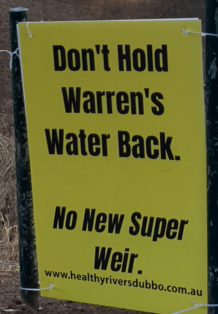
Healthy Rivers Dubbo strongly opposes this option.

Environmental Impact on the Ramsar Listed Macquarie Marshes

Only when a natural flood occurs do water birds flock to the Marshes in the hundreds of thousands to breed. It’s incredible to see.

These massive nesting events are becoming smaller due to river regulation, having shrunk from events with over a million nests before the dam went in, to about 200,000 at most now. There are significantly fewer wetlands in inland NSW that can host these massive nesting events. Globally, 70% of wetlands have been lost since 1900.

Keeping more water in the flood mitigation zone would cause natural flooding events to be suddenly cut short. This would cause water levels in the Marshes and other wetlands in the catchment to suddenly drop, having a catastrophic impact on mass water bird breeding events.

Flood water has premium environmental value to the entire ecosystem, including the recharge of ground water aquifers. Cutting short flooding events in the Macquarie/Wambuul would have the effect of further sterilising the environment.

Increasing the risk of flooding for Dubbo and Wellington

Reducing the flood mitigation zone increases the risk of an uncontrolled dam spill, which would cause significant damage to property and communities including Wellington and Dubbo. The increased risk of significant flooding in Dubbo would put upward pressure on insurance premiums and erode Dubbo’s reputation as a safe community.

Peer reviewed climate change modelling for the Central West shows flooding will become more extreme in the future – we are already experiencing larger flooding events and downpours:

  • Friday 26th November 2022 a record 220,000 ML flowed into Burrendong dam, that’s almost half of the flood mitigation zone size. If the flood mitigation zone had not been available, significant flooding would have been experienced in Wellington, Dubbo, Narromine and other communities downstream of the dam.
  • The downpours experienced around the weekend of 7th December 2024 in the upper catchment saw people clinging to trees in floodwater in Bathurst, and cars washed downstream near Mudgee.

As the climate warms there will continue to be a growing list of communities who bare economic, social and emotional scaring from increasingly large floods, for example:

  • Eugowra November 2022, two people were killed and about 150 people were airlifted off their roofs when an ‘inland tsunami’ hit the town.  
  • Grantham in the Lockyear Valley Queensland was devastated by a large flood in January 2011 that killed 12 people – the town has since been relocated.
  • Lismore on the North Coast of NSW experienced record-breaking flood that peaked more than 2 metres higher than the record. It was ranked the fourth most costly natural disaster in the world for 2022 – and the second most costly for insurers.

The proposal to reduce the flood mitigation zone in Burrendong dam, exposing all residents along the floodplain downstream of Burrendong dam to increased risk of flooding is wreckless. Communities that are built on floodplains, like Dubbo, must take every opportunity to protect themselves from the worst impacts of increasingly common and severe flooding.

Join Healthy Rivers Dubbo to stay in touch

Comments – NSW Government’s Macquarie Wambuul Water Security Project  

Healthy Rivers Dubbo is pleased to offer our comments on the options for improving water security in the NSW Government’s Macquarie Wambuul Water Security Project.  

Provide a drought reserve in Burrendong Dam to Droughtproof Dubbo

Our preferred option is that a 3 – 4 year drought reserve be established in Burrendong dam to droughtproof Dubbo. All that would be required is for a determined volume of water to be reserved, and when the dam got to that level, only water to keep the river itself and towns provided for would be released.  

At the moment there is an assumption that the dam will fill up every two years regardless of the outlook and of recent droughts, and there’s no rules to stop the dam from emptying down to zero.  

Compared to irrigation, the towns in the Macquarie Wambuul catchment use a tiny volume of water per year, less than 2% of the dam – it is profoundly unjust that entire communities and economies the size of Wellington and Dubbo should be put at risk simply because there isn’t a drought reserve in Burrendong dam.

Based on the limited data that is publicly available regarding water released from Burrendong dam, we estimate that only 11 – 12% of the dam would provide the basics for the river and towns for a year. All that would be required to droughtproof Dubbo for three years is 33 – 36% of the dam.

Expanding the use of groundwater for Dubbo’s water supply  

Groundwater is not a magic pudding and cannot be relied on indefinitely. The groundwater reserves under Dubbo are already drawn heavily on to supplement the water Dubbo draws from the river. During the millennial drought, the Government had to order Dubbo to stop drawing so much water from the aquifer as the levels had dropped dramatically. The extent to which groundwater extraction can be increased must be based on scientifically determined environmentally sustainable limits.

The use of Burrendong dam’s flood mitigation storage to increase water supply

There is an area of Burrendong Dam that is used to catch floods and release them in a controlled manner, protecting towns and property from uncontrolled flooding. There is an option in the project to use some of this space for water storage. Healthy Rivers Dubbo strongly opposes this option, as will not improve water security at all – it will simply mean even more water will be released from the dam and consumed in the same short period of time.  

  • Water supplies would not last any longer than they currently do (i.e. two years), it would just mean that more water would be extracted over the same timeframe 
  • This option would not offer additional water security for the catchment in a drought 
  • Increase the risk of dangerous uncontrolled flooding in Wellington and Dubbo 
  • Catastrophically impact water bird breeding in the Ramsar listed Macquarie Marshes

Pipeline from Dubbo to Nyngan

Healthy Rivers Dubbo accepts the need for a pipeline to Nyngan to secure water supplies out as far as Cobar. However we would prefer to see a pipeline from Warren to Nyngan replacing the Albert Priest Channel, rather than a pipeline from Dubbo to Nyngan.

We are extremely concerned that in a drought, the river would be cut off at Dubbo if that is where the pipeline commenced.

Replace Gin Gin weir

The community resoundingly rejected a proposal for a large new dam to replace the crumbling old wall that remains in the river at Gin Gin.

Any replacement of this old weir must include fish passage, and cannot be any higher, or hold back any more water than the current fixed weir.

Gin Gin dam canned

This letter confirms that the Gin Gin dam project (aka Macquarie re-regulating weir) has been cancelled.

THANK YOU to everyone who supported the campaign by making a donation, writing to the paper, a politician, signing a petition or coming along to an event on the river or a public meeting.

A great result for the river and the criters who rely on it.

Floodplain Harvesting Flow Targets we’d like to see

In July 2022, then NSW Environment Minister Griffin gave concurrence to changes to three NSW Water Sharing Plans in the Gwydir, Border Rivers and Macquarie-Wambuul Catchments that included rules on how floodplain harvesting would be managed.

When rivers levels dipped below certain heights at specific gauges, floodplain harvesting of water has to stop. These measurements are called flow targets.

Minister Griffin’s own department, the Environment and Heritage Group advised the Minister not to sign off on the water sharing plans, as the targets proposed by Nationals Water Minister Kevin Anderson are so low, they are not consistent with the objectives of the Water Management Act that requires critical human needs and the environment to be prioritised over irrigation.

Despite writing to Minister Anderson to say he would not be signing off on the Plans with the extremely poor targets, Minister Griffin did succumb to the pressure from the Nationals and signed them off.

The Environment and Heritage Group developed a set of preferred flow targets for these water sharing plans. These documents were obtained through a Parliamentary Order for Papers. Here they are.

Have your say on the future of the Belubula River

The Belubula River starts between Bathurst and Blayney, and eventually flows into the Lachlan River. The source of this river could soon be buried under 50m of toxic slurry from a proposed gold mine.

Regis Resources has applied to build a new open-cut gold mine on Kings Plain near Blayney. The mining pit would be 1km wide and 450m deep. A tailings dam wall 1.5km long and 50m tall would hold back a slurry of waste containing cyanide, mercury, lead, molybdenum and many more heavy metals – the tailings from extracting gold from the ore.

Watch a video about this destructive proposal

Submissions to the Independent Planning Commission process are open until December 21st and you can help be downloading this simple submission guide, written by the Belubula Headwaters Protection Group, and having your say.